
Monday, 18 December 2017


Thursday, 14 December 2017
3.2.1. Climate zones
- Tropical Zone
The tropical climate zone stretches from the Tropic of Cancer to the Tropic of Capricorn, with the equator centered within this zone. Climate within the tropical zone varies from:
1. The tropical wet regions of the rain forest, to the drier arid and semi-arid climate of north Within the tropical wet zone, the weather remains hot and muggy, with frequent rainfall and little temperature variation.
2. The drier arid and semi-arid regions experience wet, warm summers and cooler, drier winters, with much greater temperature variation than the tropical wet zone. This is the climate of Africa or central Australia.
- What's a Temperate Climate?
Warm summers, wet springs, colorful falls, and cold, snowy winters. Where in the world can you find these four different seasons? The temperate climate zone, that's where!
The word temperate means moderate, or in the middle. This is helpful in understanding the climate in the temperate zone - it does not have extremes. While the polar climate is extremely cold and the tropical climate is very hot, the temperate climate has some hot weather and some cold weather. While there is a lot of rain and snow in other zones, the temperate zone has just a moderate amount of rain and snow.
- Polar Zone
The polar climate zones fill the areas within the Arctic and Antarctic Circles. Characterized by a short, cool summer and long, bitterly cold winter, the polar zone features frequent snowfall, particularly during the winter months. The far northern portions of Canada, Europe and Russia fall within this climate zone. Within the ice caps, temperatures rarely, if ever, rise above freezing, even during the warmest months of the years.
CLIMATE ZONES IN SPAIN

OCEANIC CLIMATE
This is the climate of the north of the Iberian Peninsula. These are its main characteristics:
- Temperatures are warm in summer and mild in winter due to the proximity of the sea.
- Precipitation is abundant and regular throughout the year.
- Vegetation is abundant. It consists of forests with oak, chestnut and beech trees.
MOUNTAIN CLIMATE
This is the climate of mountainous regions above 1.500 meters. These are its main characteristics:
- Temperature are cool in summer and very low in winter.
- Precipitation is bundant. It often snows in winter.
- Vegetation is scarce. At higher altitudes, it consists of meadows. In lower areas, there are forests with pine, oal and fir trees.
SUBTROPICAL CLIMATE
This is the climate of the Canary Islands. This is only region of Spain that has a subtropical climate. These are its main characteristics:
- Temperatures are mild throughout the year and do not vary much.
- Precipitation is higher in the northern parts of islands. In contrast, it is scarce in the south of the islands and in the islands closest to Africa, such as Lanzarote and Fuerteventura.
- The vegetation includes laurel forests, Canary Island pines, palm trees and dragon trees.
MEDITERRANEAN CLIMATE
This is the most common climate in Spain. There are three variations:
- TYPICAL MEDITERRANEAN CLIMATE. This is the climate of the Balearic Islands, most of the Mediterranean coast and a few areas of the Iberian Peninsula. Temperatures are high in summer and mild in winter. Precipitation is scarce and irregular. Rainfall is highest in spring and autumn. Drought is common in summer.
- CONTINENTAL MEDITERRANEAN CLIMATE. This is the climate of most areas of the Iberian Peninsula. Temperatures are high in summer and low in winter. Precipitation is scarce. It sometimes snows in winter.
- DRY MEDITERRANEAN CLIMATE. This is the climate of the southeastern areas of the Iberian Peninsula. Temperatures are mild along the coast and extreme inland. Precipitation is very scarce throughout the year, with extremely dry summers.

Sunday, 10 December 2017
3.3. Advances in medicine

Before starting ⇨ Complete the routine See/Think/Wonder
- What do you see?
 What do you think about that?
- What does it make you wonder?

1. PREVENTION of illnesses: vaccination
 One way of developing immunity to some infectious diseases is through vaccination.
 A vaccine is a dose of the weakened virus or bacteria which stimulates the white blood cells to make antibodies.
Vaccines work by exploiting the immune system’s memory. Vaccination simulates an infection, training the immune system and enabling it to develop weapons to fight back.
➨ Who discovered vaccines?
2. DIAGNOSIS of illnesses
Diagnosis is the act of identifying and illness based on symptoms and test.
In 1895 a scientist accidentally discovered a form of electromagnetism radiation that could pass through the body and leave an image of the bones and organs on a photograph plate.
The discovery of these Xrays led to a medical revolution and helped doctors make more accurate diagnoses.
3. TREATMENT of illnesses
In 1928 the scientist Alexander Fleming made an accidental discovery. He noticed that when mould grew on a bacteria dish the bacteria near the mould died.Chemists separated the substance, called penicillim, from the mould. Today doctors treat many kinds of infectiones with penicillin and it has saved many lives.
Chemists have found ways to make similar substances which kill bacteria. These medicines are called antibiotics.


➡ What are painkillers?
➨ Choose one illness to investigate and complete a graphic organiser

4. NEW TECHNIQUES in surgery
Since the invention of anaesthesia in 1800, there has been lots of advances in surgery. Microsurgery allows surgeons to operate on microscopic parts of the body, such as damaged nerves or capillary blood vessels, by using a special microscope.
Other advances in medicine. Complete:
 |
| Añadir leyenda |
- 1818
- 1922
- 1952
- 1954
- 1978
- 1996
- 2004
Monday, 4 December 2017
SC 3.2. CLIMATES
FACTORS THAT AFFECT CLIMATE

1. Latitude
It is the measurement of the distance of a place from the Equator. It affects the temperature of a place. Equatorial regions are warmer than polar regions.

2. Landform or relief
Mountain ranges can stop seas air from reaching inland areas. This means inland temperatures are more extreme than temperatures on the coast. Landform can also affect the amount of rainfall an area receives.

3. Altitude
It is the height above sea level of an area. places at higher altitudes are usually cooler than places at lower altitudes. Clods can't hold large amounts of water when it's cold, so there's often more precipitation at higher altitudes.

4. The distance from the sea
Water heats up more slowly than land, but it also cools down more slowly. This means that places near the coast have more even temperatures than island places, where temperature differences are more extreme. In comparison, coastal areas are cooler in the summer and warmer in winter.

Sunday, 3 December 2017


Monday, 27 November 2017
SC UNIT 3: CLIMATE AND WEATHER
We are going to learn about:
- The Earth's different climates and why these differences happen.
- The climate in Spain.
- How human activity contributes to climate change.

CLIMATE
Climate refers to the general weather conditions we can expect in particular geographical areas over a long period of time (about 30 years). Around the world, there are different climates, which affect the lives of people, animals and plants.
It is different from weather, which just describes the conditions for a few hours.
WEATHER
It is the state of atmosphere in a specific place and time. it depends on:


- The Earth's different climates and why these differences happen.
- The climate in Spain.
- How human activity contributes to climate change.

CLIMATE
Climate refers to the general weather conditions we can expect in particular geographical areas over a long period of time (about 30 years). Around the world, there are different climates, which affect the lives of people, animals and plants.
It is different from weather, which just describes the conditions for a few hours.
WEATHER
It is the state of atmosphere in a specific place and time. it depends on:
- air temperature
- humidity levels
- precipitation
- wind
- atmospheric pressure


A THERMOMETER measures the air temperature. Most thermometers are closed glass tubes containing liquids such as alcohol or mercury. When air around the tube heats the liquid, the liquid expands and moves up the tube. A scale then shows what the actual temperature is.
An ANEMOMETER measures wind speed. The cups catch the wind, turning a dial attached to the instrument. The dial shows the wind speed.
A HYGROMETER measures the water vapor content of air or the humidity.A RAIN GAUGE measures the amount of rain that has fallen over a specific time period.
A WIND VANE is an instrument that determines the direction from which the wind is blowing.
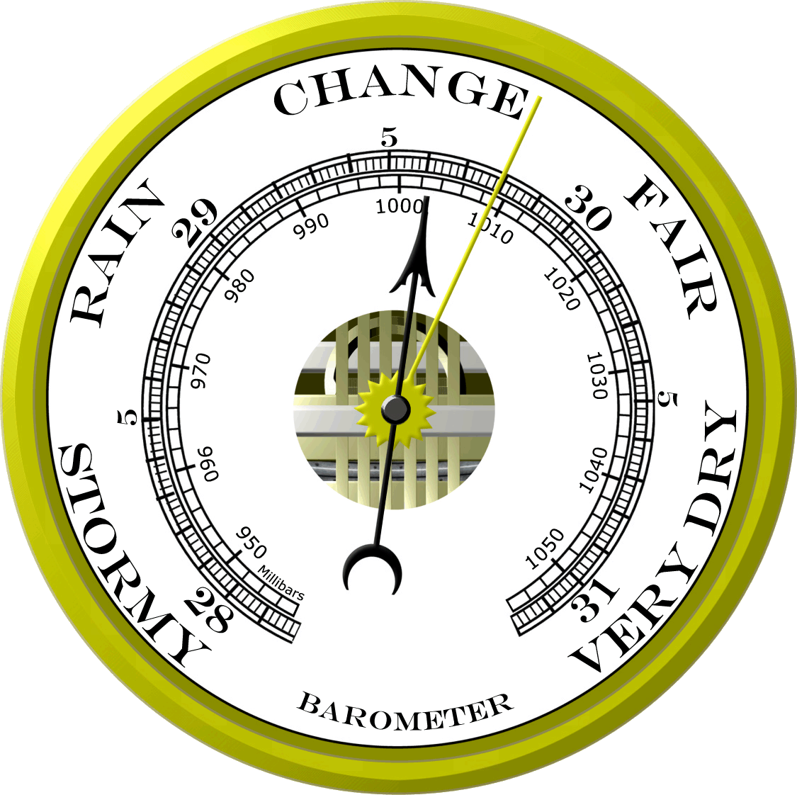
A BAROMETER measures air pressure. It tells you whether or not the pressure is rising or falling. A rising barometer means sunny and dry conditions, while a falling barometer means stormy and wet conditions. An Italian scientist named Torricelli built the first barometer in 1643.
Sunday, 26 November 2017
UNIT 3: HEALTH AND ILLNESS
3.1. Diseases and illnesses.
We are going to learn about types of diseases:
- Infectious diseases (caused by pathogens).
- Non-infectious diseases.
Before starting -> Make a list of the things you do to prevent an illness.

INFECTIOUS DISEASES such as common colds, are caused by harmful organisms called pathogens entering our body.
The most common pathogens are bacteria and viruses. Other microorganisms, such as some kinds of fungi and protists, can also cause diseases.
Bacterias
Viruses
NON-INFECTIOUS DISEASES such as diabetes, are not caused by organisms. They are caused by different factors and cannot be spread from person to person.
A healthy lifestyle helps prevent diseases. This includes a healthy diet, exercise, regular check-ups, and saying no to drugs and alcohol and an excessive use of video games.

 The immune system is a network of cells, tissues, and organs that work together to defend the body against attacks by “foreign” invaders. These are primarily microbes—tiny organisms such as bacteria, parasites, and fungi that can cause infections.
Most common infectious diseases

Tuesday, 21 November 2017
MIND MAPS
Definition of a Mind Map
A mind map is a visual representation of organised information that includes a central idea surrounded by connected branches of associated topics.
Benefits of Mind Maps
- Help you brainstorm and explore any idea, concept, or problem
- Facilitate better understanding of relationships and connections between ideas and concepts
- Make it easy to communicate new ideas and thought processes
- Allow you to easily recall information
- Help you take notes and plan tasks
- Make it easy to organize ideas and concepts


And these are our first attempts. Not bad, isn't it?


Friday, 17 November 2017

Sunday, 29 October 2017
2.3 MAPS
What are we going to learn?
- Different types of maps.
- To identify and interpret the key and the scale on a map.
- To follow directions and locations on a map.
THE LANGUAGE OF MAPS
Absolute Location: describes the exact position of a point, often using latitude and longitude. “Kenya’s latitude and longitude is 1° 00′ N and 38° 00′ E; that is 1° north of the equator, and 38° east of the prime meridian.”
Relative Location: finds the location of a place using other surrounding places, or by using cardinal directions. “Kenya is south of Ethiopia, north of Tanzania, east of Uganda, and west of Somalia and the Indian Ocean.”
Cardinal directions: The four cardinal points are north, south, east, and west.
Intermediate directions: The points that fall between the cardinal directions: Northeast (NE), southeast (SE), southwest (SW), and northwest (NW)
Compass rose: A figure on maps to display the orientation of the cardinal directions.
Coordinates: A set of values that show an exact position, for example how many degrees east of west of the prime meridian, and north or south of the equator.
Map key or legend: Usually in a corner of the map, the “key” or “legend” is a small table of symbols that is used on the map, with their explanations.
Scale: it shows the relationship between the distances on the map and the actual distances on the Earth.

Physical maps: The purpose of physical maps is to show geography of land types, bodies of water, and landforms such as deserts, mountains, and arctic regions.
Political maps: The purpose of political maps is to show territorial borders, major cities, and capitals.
Relative Location: finds the location of a place using other surrounding places, or by using cardinal directions. “Kenya is south of Ethiopia, north of Tanzania, east of Uganda, and west of Somalia and the Indian Ocean.”
Cardinal directions: The four cardinal points are north, south, east, and west.
Intermediate directions: The points that fall between the cardinal directions: Northeast (NE), southeast (SE), southwest (SW), and northwest (NW)
Compass rose: A figure on maps to display the orientation of the cardinal directions.
Coordinates: A set of values that show an exact position, for example how many degrees east of west of the prime meridian, and north or south of the equator.
Map key or legend: Usually in a corner of the map, the “key” or “legend” is a small table of symbols that is used on the map, with their explanations.
Scale: it shows the relationship between the distances on the map and the actual distances on the Earth.

Physical maps: The purpose of physical maps is to show geography of land types, bodies of water, and landforms such as deserts, mountains, and arctic regions.
Political maps: The purpose of political maps is to show territorial borders, major cities, and capitals.
PHYSICAL MAPS
Earth's surface is shaped in many ways. These different shapes are called landforms. Mountains, valleys, plateaus, and plains are all examples of Earth's landforms. This diagram shows some of the landforms and bodies of water on Earth.
- Which landform is the highest?
- Which landforms are flat?
- Which are bodies of water?
- Can you name other landforms that you don’t see on this drawing?
- Which of these landforms are near our hometown?
LANDFORMS

POLITICAL MAPS
Political maps show countries, their borders and capital cities.


Tuesday, 24 October 2017
2.2. Cartography
Geographic coordinates
PARALLELS are circular lines that go around the Earth from east to west.
MERIDIANS are circular lines that go from north to south and pass through the poles. The Prime Meridian, also called the Greenwich Meridian, divides Earth into the eastern hemisphere and the western hemisphere.
Listen to this SONG about maps:
Answer in your notebook:
- What is latitude?
- What is longitude?
Subscribe to:
Posts (Atom)